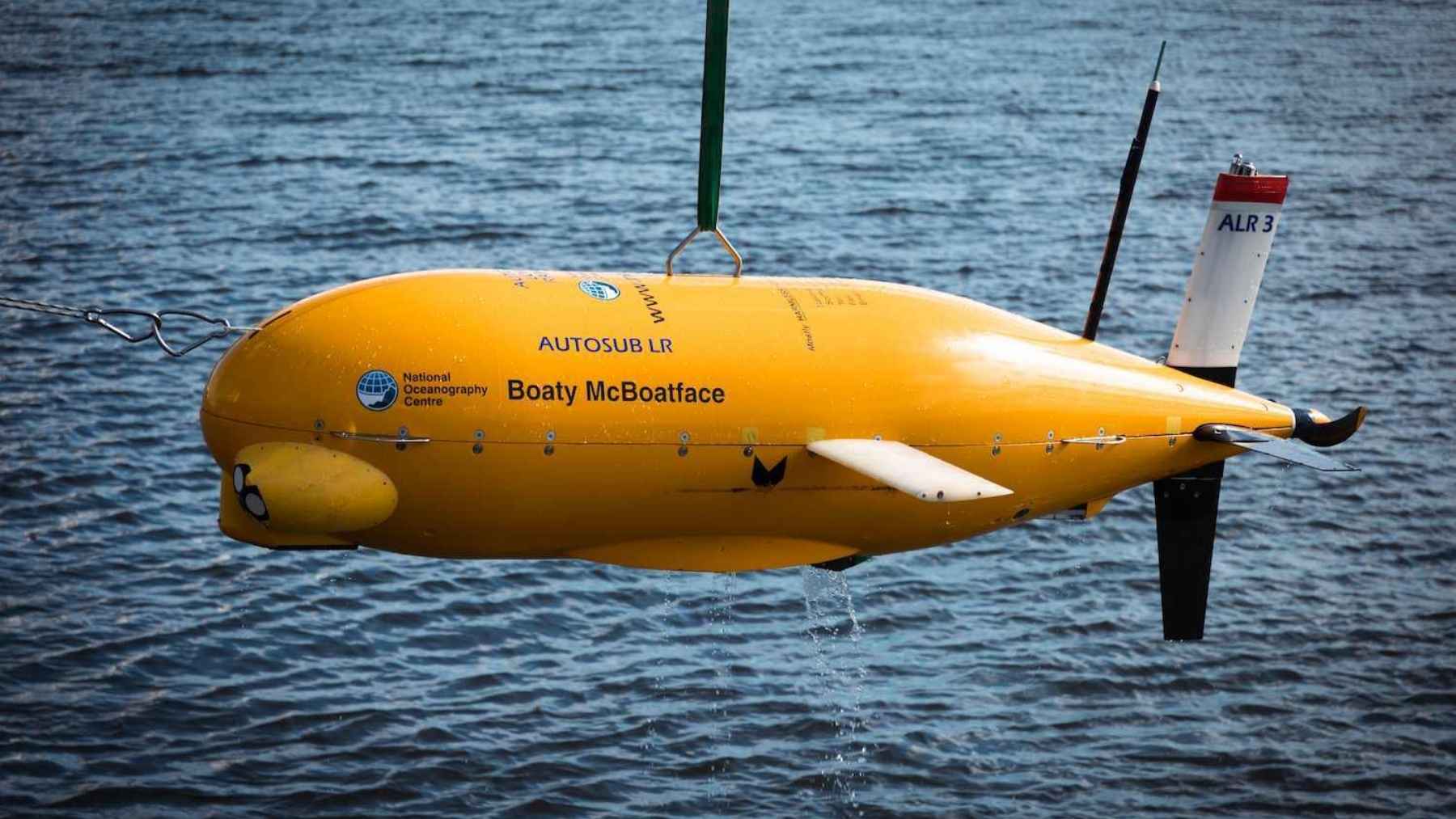

In 2016 the UK’s Natural Environment Research Council let the public name a new polar research ship. The public came back with Boaty McBoatface, on 124,109 votes. Science minister Jo Johnson overruled the poll, named the ship RRS Sir David Attenborough, and parked the joke on a yellow submarine that rides on the back of it.
That submarine just came home from the one job on the trip no ship could do.
The RRS Sir David Attenborough docked at Harwich International Port at around 2pm on August 27, closing out a six-week expedition to southeast Greenland. It had sailed on July 16 with nine autonomous systems strapped to the aft deck. Boaty was the only one sent under the ice.
The public voted, the government said no, and the submarine kept the name
James Hand, a former BBC radio presenter, submitted Boaty McBoatface to the naming poll and then apologised for it in public. RRS Poppy-Mai finished second. Jo Johnson announced the Attenborough name in May 2016, and NERC confirmed that the winning entry would live on as an undersea vehicle instead.
The vehicle it landed on is an Autosub Long Range, designed and operated by the National Oceanography Centre in Southampton. NOC engineers published its dimensions in Ocean Engineering in 2023: 11 feet 10 inches long (3.6 meters), 31 inches across, 1,653 pounds (750 kilograms) dry. A 24-volt, 170-watt brushless motor turns a 24-inch propeller through a 26:1 gearbox, and that is the whole propulsion system.
It cruises between 1.0 and 2.0 mph (0.45 to 0.9 meters per second). The NOC’s public specification puts its range at 1,243 miles (2,000 kilometers), which buys missions measured in weeks rather than hours, and ALR vehicles have already worked under the Ronne-Filchner Ice Shelf in Antarctica.
It talks to an Iridium satellite. The vehicle surfaces, sends its data to shore, picks up new orders and goes back down, so nobody has to recover it to find out what it found. That satellite link is how a team in Cambridge can retask a machine sitting off Greenland without moving a ship.
An ice mélange is the one place a ship cannot follow
Kangerlussuaq and the glaciers around it end in vertical cliffs up to 328 feet (100 meters) tall. Ice breaks off those cliffs constantly. The debris piles up in the fjord as a mélange, a dense slush of sea ice and iceberg chunks that the British Antarctic Survey describes as choking the water in front of the calving face.
No ship goes in there.
That jam is not passive. It presses back against the glacier and slows its flow into the ocean, and when the summer clears it out, calving rates climb and the glacier can retreat fast. Satellites map the top of it in detail. The underside has never been surveyed. Boaty’s assignment was to dive to 4,921 feet (1,500 meters), get beneath the jam and map its geometry, which is the measurement that tells modellers how hard the brake is actually pressing.
Sam Smith, an operations engineer at the National Oceanography Centre, told Reuters before departure that the vehicle would be “collecting a lot of data that’s never really been collected before.”
Nine systems went north, and each one covers a gap the others cannot
DriX skims the surface and sweeps the submerged glacier face with scanning sonar, feeding back melt rates and water properties on a daily and sometimes hourly clock. Gavia and EcoSub vehicles dive as a coordinated team, holding station on each other acoustically, and get closer to the wall than DriX can.
Meltstake is the strange one. A self-driving boat delivers it to the glacier face, a remotely operated diving vehicle carries it down, and then it screws itself into the ice and keeps screwing as the wall melts backwards, so its cameras, hydrophones and acoustic scanners stay pinned to a surface that is retreating underneath them.
Erin Pettit, a professor at Oregon State University who works on the instrument, has said the ice helps destroy itself: pressurised bubbles burst out of the melting face, churn the boundary layer and drive more melting.
On the glacier surface, Adios units go in by helicopter and read the internal ice layers with radar. Geopebbles, GPS-enabled seismic sensors, sit on the ice and log every crack and calving event.
Machines like these are stacking up fast across ocean science. A drone submarine named Ran had already produced the first map of the underside of an Antarctic ice shelf before disappearing on a later dive, a French AUV counted 3,355 drums of dumped nuclear waste on the Atlantic floor in 26 days, and a Norwegian one read a volcanic ridge in the Arctic down to five centimeters.
A glacier front dropped 19.8 million tons while the ship watched from half a mile out
The expedition was working near Sorgenfri Gletsjer, at the head of 3-miippugut Fjord north of Kangerlussuaq Fjord, when a section of the front let go all at once in the evening.
BAS put the slab at 3,280 feet (1 kilometer) across the ice face and 328 feet (100 meters) thick on average, for an estimated 19.8 million tons (18 million metric tons). The ship sat more than half a mile off when it went.
Captain Matt Neill, Master of the RRS Sir David Attenborough, said in the BAS account of the event that it was “incredible to see such a volume of ice shifting,” and that his crew turned the ship as the calving started.
BAS was careful to add that calving is normal summer behaviour for an ocean-terminating glacier, even while the ice sheet loses mass at record rates. It is also the exact process the fleet was sent to measure, which is why the footage matters beyond being a good video.
Nobody drives Boaty, and a lot of the coverage says otherwise
Local Essex papers reporting the ship’s return on August 27 described the submarine as remotely operated. Fox News called it remote-controlled back in 2016. The NOC lists it as an autonomous underwater vehicle with a crew of zero, pre-programmed before each launch.
The distinction is not pedantry. Under a mélange there is no tether to run, no radio link to hold, and no way for anyone on the ship to intervene. The vehicle goes in with a plan and comes out on that plan, or it does not come out, which is what happened to Ran under the Dotson Ice Shelf.
Kangerlussuaq this year, Petermann next
All of it sits inside GIANT, short for Greenland Ice sheet to AtlaNtic Tipping points from ice loss. The project runs five years on £20 million (about $27 million), led by the British Antarctic Survey and funded by the Advanced Research and Invention Agency under its Forecasting Tipping Points programme. GIANT pulls in 15 collaborating institutions and five technology partners across the UK, US and Europe, and it is the largest of the 25 teams in that programme.
The worry driving it runs through the North Atlantic Subpolar Gyre. Meltwater pouring off Greenland’s glaciers is fresh and cold, and enough of it can cap the gyre, stop the water beneath from sinking and slow the Atlantic Meridional Overturning Circulation that carries heat north. Greenland holds enough ice to raise global sea level by more than 23 feet (7 meters), and it delivers that water through a coastline of over 200 narrow fjords that current climate models represent badly.
Kelly Hogan, the BAS marine geophysicist leading GIANT, has framed the moment as one where the tools finally caught up with the questions.
The 2027 campaign moves northwest to Petermann Glacier and its floating tongue. An 11.5-foot vehicle called Icefin goes down a drilled borehole to the grounding line, where the ice starts to float, and a Windracers ULTRA drone with a 32.8-foot wingspan maps the surface from above to work out where to drill.
Everything from this summer feeds a next-generation UK Earth System Model and a prototype early warning system for rapid glacier change.
None of the mélange measurements have been published. Kelly Hogan’s team came off the ship at Harwich on August 27 with six weeks of raw data, and the first Petermann fieldwork is not scheduled until 2027.