The whole point of a submarine is that nobody can find it. That has been the deal since the early 1900s: a boat slides under the surface, goes quiet, and turns into a hole in the ocean the other side has to guess at.
American deterrence and submarine strategy have leaned on that disappearing act for decades, and it has worked for one simple reason. The deep ocean is genuinely hard to see into.
China has spent the last decade trying to change that. Not by building better submarine hunters, but by wiring the ocean itself so the boats have nowhere left to hide.
The effort goes by a few names. Chinese researchers call it the “Transparent Ocean.” Western analysts borrowed an older label from a 2016 Jane’s report and call the seabed piece an “underwater Great Wall.” Either way the idea is the same: blanket the western Pacific and beyond with enough sensors, drones and satellites that a submerged submarine stops being invisible and starts being a track on a screen.
It is not science fiction, and it is not finished. But it is real, it is being built right now, and the U.S. Navy has started saying so on the record.
The fleet quietly mapping the ocean floor
You cannot make the ocean transparent without first knowing exactly what is down there. Sound bends, scatters and disappears depending on water temperature, salinity and the shape of the seabed, so the first job is a giant survey.
A Reuters investigation published on March 24 used ship-tracking data to map that survey, and the numbers are not subtle. At least 42 Chinese research vessels have worked the Pacific, Indian and Arctic oceans for more than five years, dropping hundreds of sensors as they go.
One ship explains the pattern. The Dong Fang Hong 3, officially a general-purpose science vessel, ran repeat surveys between 2024 and 2025 in three very specific places: the waters near Taiwan, the approaches to Guam, and key stretches of the Indian Ocean.
In March 2025 it laid down dense survey tracks between Sri Lanka and Indonesia, right at the mouth of the Malacca Strait. None of those are random fishing spots. They are exactly where American and allied submarines transit.
Those 42 ships are drawn from a much bigger pool. According to a March 2026 analysis in the U.S. Naval Institute’s Proceedings, China now runs 64 oceanographic research vessels, most of them built in the last 15 years. That is a bigger fleet than the U.S. academic research fleet, NOAA’s fleet and the Navy’s own survey ships put together.
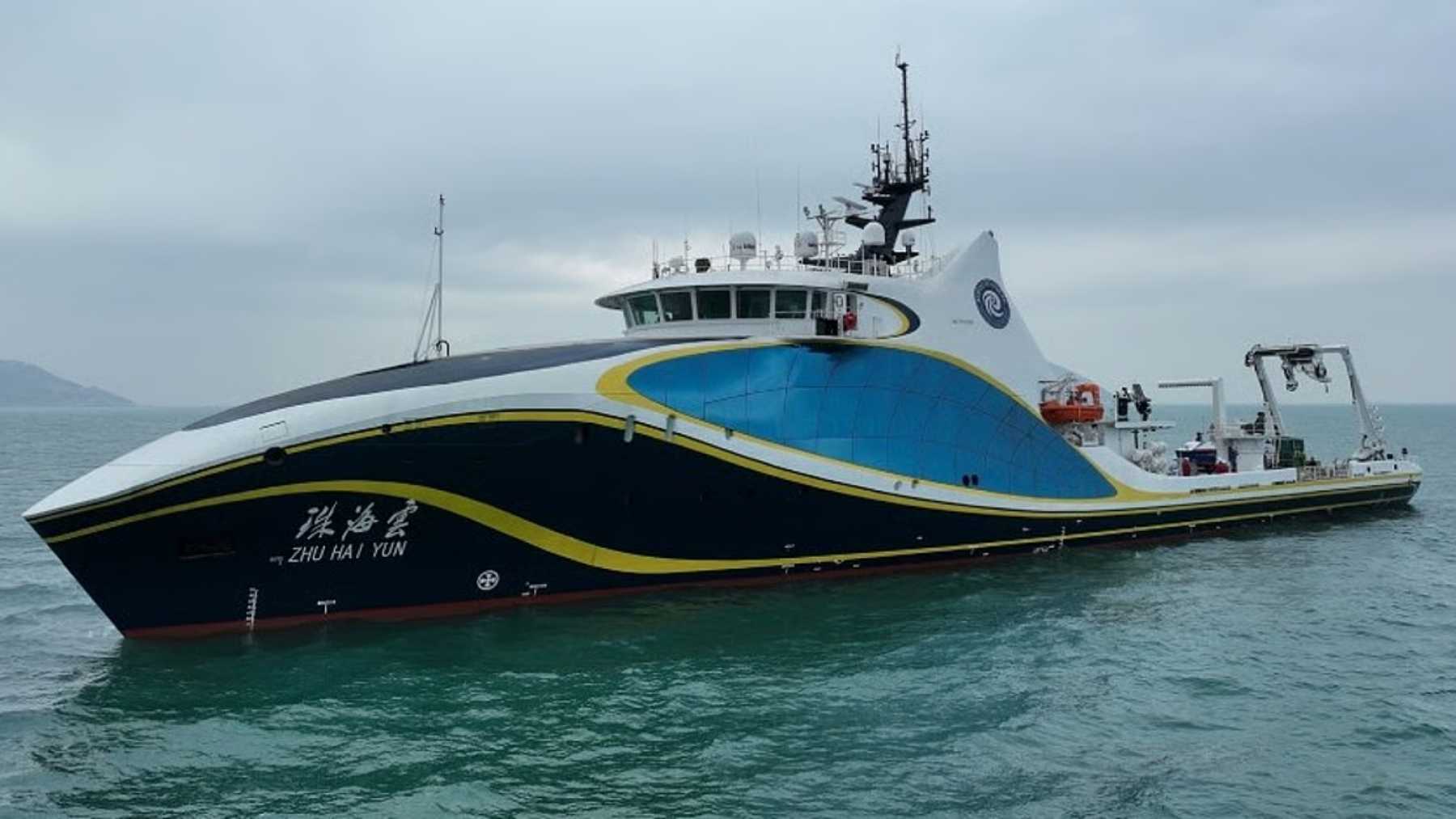
The mapping does not stop at crewed ships. China’s showpiece is the Zhu Hai Yun, a drone mothership that can run more than 50 uncrewed vehicles at once: aerial drones, surface boats and underwater gliders, covering a patch of sea about 160 kilometers across while it keeps moving.
Then there are the big robots. China has built five extra-large uncrewed underwater vehicles in the 15-to-20-meter range, and is testing two genuinely enormous ones, each more than 40 meters long, about the length of a crewed diesel submarine.
They can map the seabed, carry torpedoes or mines, and the largest are big enough to drag towed-array sonar across the Pacific. Those drones are a story in themselves, and we have dug into the giant ones separately.
Five layers, from the seabed to space
The sensors and ships are only the raw material. What turns the Transparent Ocean into a system, rather than a pile of hardware, is how the pieces are meant to talk to each other.
Defense One laid out the architecture in detail, and it stacks into five layers running from orbit down to the seafloor.
At the top sits a constellation of satellites, built around a radar-and-lidar system called Guanlan, that scans wide areas of sea surface and flags anything suspicious. Its job is to tell the lower layers where to look.
Below it, at the surface, smart buoys, wave gliders and uncrewed boats hold station over straits and shelves. Their main role is translation: turning slow, faint underwater acoustic signals into fast satellite or cellular bursts that can reach shore.
In the water column, deep floats and long-range gliders patrol for weeks at a time. They profile the ocean and tow acoustic gear to fill the gaps the satellites cannot reach.
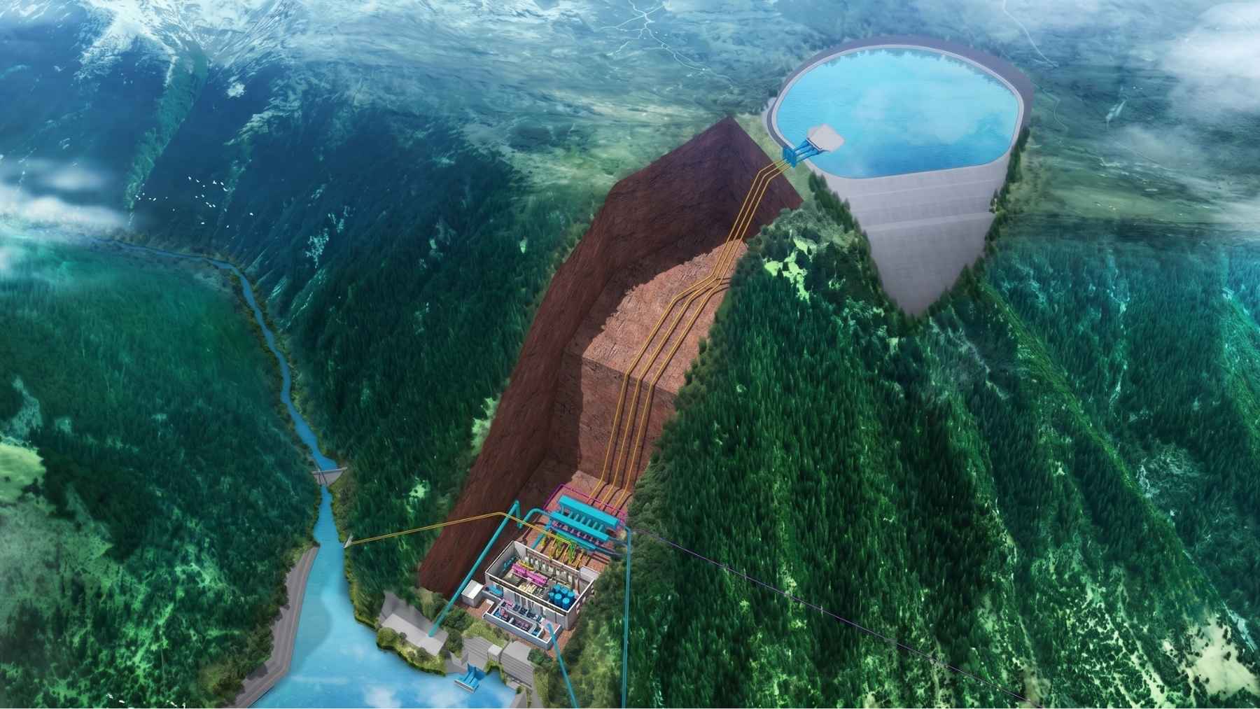
The backbone is on the seabed. Cabled observatories host passive listening arrays, precise clocks and navigation beacons, and they double as docking and recharging stations so uncrewed submarines can loiter and redeploy without ever surfacing.
Tying it all together is a data-fusion brain that merges everything into one picture and, in theory, hands targets straight to the shooters.
That last part is the doctrine talking. Chinese military theorists have written about moving from a brittle “kill chain,” which breaks the moment you knock out one link, to a “kill web” that simply reroutes around damage. A transparent ocean is what automates that web at scale.
The U.S. Navy is starting to say it out loud
For a while this was the kind of thing that lived in think-tank PDFs. That has changed.
In congressional testimony this spring, senior U.S. Navy officers including Vice Admiral Richard Seif described China’s effort as a layered undersea surveillance architecture aimed squarely at contesting where American submarines can go, built from fixed sensors, uncrewed systems and data networks knitted across chokepoints. The operational goal, as he framed it, is to chip away at the stealth edge U.S. boats rely on by simply knowing the seabed better than anyone else.
Rear Admiral Mike Brookes made a related point in separate testimony: all this ocean data is dual-use by design. The same surveys that support climate science also support sea denial, deterrence and strikes on high-value targets.
The Proceedings analysis put a clock on it. Its author, retired Navy Captain Emil Petruncio, argues China has already closed the gap in one of the few areas where the United States held a clear edge, quiet submarine operations, and that by the end of its current five-year plan Beijing could reach rough parity with U.S. naval capability in the western Pacific.
You do not have to take any single source’s word for it. The bipartisan U.S.-China Economic and Security Review Commission has heard the same thing. In March testimony, defense scholar Michael Horowitz told the commission that no other country, the United States included, is chasing undersea autonomy at China’s scale and speed, and that Beijing wants to “turbocharge” the whole effort with quantum sensing.
The quantum wild card
Quantum sensing is where this gets either genuinely alarming or wildly overhyped, depending on who is talking.
The pitch is that you can find a submarine without listening for it at all. A steel hull the size of a building distorts the local magnetic, and even gravitational, field by a hair. Quantum sensors are sensitive enough, in principle, to feel that hair.
In early April, the South China Morning Post reported that a team at the Chinese Academy of Sciences had demonstrated a compact gravity sensor, roughly the size of an office cubicle, that works outside the lab and approaches the sensitivity of a full observatory. It was built for geophysics, but it is now openly discussed as an anti-submarine tool, because a sub’s mass quietly bends the space around it as it moves.
Chinese groups have also tested drone-mounted quantum magnetometers, and systems that hunt the faint magnetic trail left in a submarine’s wake.
Here is the cold water. U.S. analysts who have looked at the same claims keep landing in the same place: these are demonstrations, not fielded weapons, and none of them makes an American attack or missile submarine obsolete today. China has a long habit of showing off concept hardware years before it works at sea.
So is the ocean actually transparent yet?
Short answer: no.
The longer answer is that almost everyone serious about this, including the people building the technology, treats it as a 2030s problem rather than a today problem.
Writing in The Conversation, defense researcher David Stupples compared the shift to the way radar made the skies transparent a century ago, and put the ocean’s turn somewhere in the mid-2030s while calling the full vision “technically ambitious” for now.
The ocean is just a brutally hard place to see into. Temperature layers, salinity gradients and seabed terrain all bend and swallow signals, which is exactly why this took a decade of mapping and still is not done.
There is also the small matter of the submarines fighting back. The same season China is wiring the seabed, the United States, Britain and Australia are funding fleets of uncrewed undersea drones, partly to guard the seabed cables China’s sensors sit near, partly to keep their own boats relevant. We broke down that side of the deal when the three governments rewrote their submarine pact.
One node of China’s grid has even turned up in the wrong hands: a sensor mooring that washed into an Indonesian fisherman’s net earlier this year, hauled up from one of the few straits deep enough for a submarine to slip through unseen.
What China is building is real, it is enormous, and it is pointed directly at the one trick that has made submarines worth their staggering price for a hundred years. What it is not, yet, is finished.
The deep Pacific is still mostly dark. The bet Beijing is making is that it will not stay that way. And the bet Washington is making, judging by where the money is going, is that the smartest move now is to stop assuming the ocean will hide anything at all.