We have maps of nearly everything now. You can pull up your own roof from orbit on your phone, scroll across the far side of the moon, and stare at the surface of Mars without getting off the couch. One place all that satellite hardware never reached, though, is the underside of a floating Antarctic glacier. Not the top of the ice that satellites photograph on a loop, but the bottom face, the part sitting in the water where the ocean quietly eats the glacier from beneath. You cannot see that from space. Somebody has to physically put a machine under the ice.
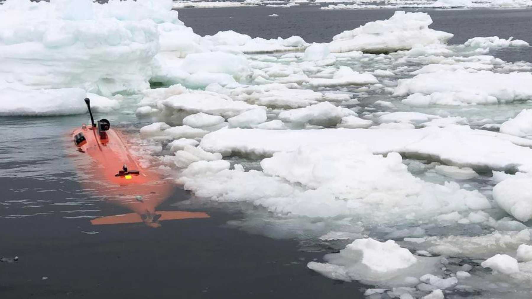
So the University of Gothenburg did. An autonomous underwater vehicle named Ran, a torpedo-shaped robot submarine, was programmed to dive into the cavity beneath the Dotson Ice Shelf in West Antarctica and scan the ceiling of ice above it with sonar.
Over 27 days it drove more than 1,000 kilometers (about 620 miles) back and forth in total darkness, pushing as far as 17 kilometers (about 10.6 miles) into the cavity, under ice roughly 350 meters (1,150 feet) thick. It came back with the first detailed map of the bottom of a glacier anyone has ever made. Then, on a later trip, it didn’t come back at all.
Ran spent 27 days mapping a place nobody had ever seen
An ice shelf is the floating front end of a glacier, a slab of land ice that has slid out over the ocean and now bobs on top of a cavity of seawater. Satellites are great at the top surface and useless at the bottom one, because radar and cameras cannot see through hundreds of meters of ice. Ice cores and drill holes give you a few pinpricks of data. What nobody had was an actual map of the whole underside.
Ran got one by doing something ships cannot. An autonomous underwater vehicle runs without a cable and without anyone steering it, making its own decisions from sensor data as it goes, which lets it reach places a crewed sub or a tethered robot cannot follow.
Ran carried an advanced multibeam sonar pointed upward and mapped the base of the ice from about 50 meters (165 feet) below it. Robot submarines are having a moment elsewhere too, mostly in defense, where navies are fielding autonomous machines like the U.S. Navy’s containerized Speartooth drone submarine and running trials where a French nuclear sub launches a U.S. Razorback underwater drone while submerged. Ran’s job was the science version of the same trick: go where humans cannot, and come back with data.
When the data came up off the icebreaker, the team realized they were looking at something no one had seen. “It’s a bit like seeing the back of the moon,” said lead author Anna Wåhlin, Professor of Oceanography at the University of Gothenburg. That was not a throwaway line. The underside of the Dotson Ice Shelf had been, until that moment, a genuine blank on the map of Earth.
The underside of the ice is not smooth
Everyone sort of assumed the bottom of an ice shelf was a flat sheet. It is not. Ran found a carved-up landscape down there, with peaks and valleys, flat plateaus, terraces stacked like stair steps, and teardrop-shaped pits gouged into the ice. In some areas the surface looked like sand dunes. The researchers think those shapes were sculpted by water flowing under the influence of Earth’s rotation, the same Coriolis effect that spins hurricanes and ocean currents, only here it is etching patterns into the bottom of a glacier.
The map also explained why one side of Dotson melts so much faster than the other. Around Antarctica there is a warm, salty current called Circumpolar Deep Water that pushes up onto the continental shelf, slides into the cavity under the ice, and melts the glacier from below. Ran measured those currents directly for the first time and found the heaviest melt concentrated on the western side and along vertical fractures running up through the ice.
Some of it lined up with what models predicted. A lot of it did not. Wåhlin’s read was blunt: current models cannot explain the complex patterns the robot found, and plenty of long-standing assumptions about how glaciers melt from underneath are coming up short.
That matters more than it sounds, because how fast the underside melts is one of the biggest unknowns in every sea-level forecast we have.
Then Ran went back, and didn’t come out
The mapping run happened in 2022. In January 2024 the team returned to Dotson with Ran to repeat the surveys and document how the ice had changed. They managed exactly one dive. On the next one, Ran went under the ice and never came back. No signal, no debris, no rendezvous. The team can only guess at what happened, somewhere on the spectrum from mechanical failure to a collision with an ice ridge in the dark.
Wåhlin has been clear-eyed about it. Watching the robot disappear into the dark and carry out its tasks for more than 24 hours with no way to reach it was, she has said, unnerving, and more than 40 earlier missions under the ice had not been enough to beat the environment this time. She also pointed out that the data Ran already sent back is unique in the world, and that for a machine built to take risks no person could, disappearing on the job beat slowly gathering dust in a garage.
The glacier next door is about to lose its brake
Here is why a robot mapping the bottom of one ice shelf is more than a neat trick. Dotson is part of the West Antarctic Ice Sheet, the chunk of Antarctica scientists actually lose sleep over. Right next door sits Thwaites, the one the press nicknamed the “doomsday glacier,” and in 2026 its eastern ice shelf is coming apart. Robert Larter, a marine geophysicist at the British Antarctic Survey who runs the U.K. side of the International Thwaites Glacier Collaboration, told Live Science the last stretch of shelf in front of the glacier is “poised to disintegrate.” Karen Alley, the University of Manitoba glaciologist who co-authored Ran’s Dotson maps, is one of the scientists now tracking that breakup from satellite images.
An ice shelf works like a doorstop. It floats in front of the glacier and braces the grounded ice behind it, slowing how fast that ice slides into the sea. Remove the doorstop and the glacier speeds up. If Thwaites itself fully collapsed, that alone would raise global sea level by about 65 centimeters, roughly 2 feet.
But Thwaites is also the cork in a much bigger bottle. If its loss helped unspool the entire West Antarctic Ice Sheet, the British Antarctic Survey puts that at around 3.3 meters of sea-level rise, close to 11 feet, enough to redraw coastlines worldwide. Nobody is saying that happens next year. The whole process plays out over centuries. But the maps Ran made of how warm water carves ice from below feed directly into the models trying to pin down how fast.
A replacement is finally coming, and it goes deeper
For a while it looked like that work was stuck, because Ran was irreplaceable and gone. Then in late 2025 the University of Gothenburg confirmed it is getting a successor, Ran II, a new Kongsberg HUGIN vehicle paid for by a major donation from the Voice of the Ocean Foundation plus insurance money. The new robot is rated to 3,000 meters (about 9,800 feet) deep and comes with more robust emergency decision-making and better navigation, the two things most likely to keep it from repeating Ran’s fate under the ice. Delivery is expected in the winter of 2026/2027.
When Ran first launched in 2018, it was one of only three research submarines of its kind anywhere on the planet, and the only one in Sweden. The full study sits in Science Advances, but the short version is simpler than the science: the bottom of the ice turned out to be where the real story is, and it is worth risking a multimillion-dollar machine to get there. Ran II is how the team goes back for the rest of the map. This time, with any luck, it drives back out.