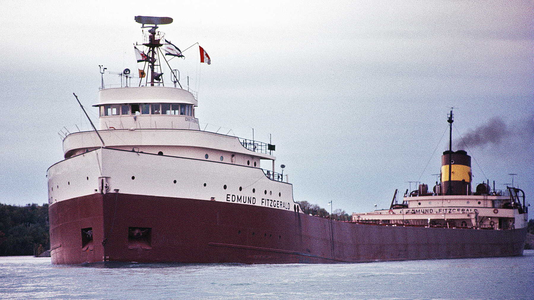

Most people know the Edmund Fitzgerald from a song. Gordon Lightfoot’s 1976 ballad has kept that ship’s name alive longer than any government report could have, and on Tuesday, November 10, it’ll be 51 years since she went down on Lake Superior with all 29 men aboard.
But the government did write reports, and one of them has a number Lightfoot never got around to singing about. On page 3 of a risk assessment NOAA published in March 2013, in a table you’d never read for fun, there’s a line for the fuel oil probably left on the wreck. It says up to 1,191 barrels.
So is there really that much oil sitting at the bottom of Lake Superior?
Maybe. “Up to” makes that a ceiling, and nobody had reported a leak when NOAA wrote it. So I went through the federal paperwork to see what it actually says, and what it doesn’t.
So what’s down there?
The Fitzgerald was 729 feet long, 75 feet wide and 13,632 gross tons, and she was the biggest ship on the Great Lakes until 1971, according to the Great Lakes Shipwreck Historical Society. Gross tons measure how much room a hull encloses, so don’t read that as her weight on a scale.
Her last load was 26,116 long tons of taconite, which is basically iron ore that’s been processed into pellets about the size of marbles. She was headed for Detroit by way of Sault Ste. Marie, the same chokepoint where the Army’s now building a 1,200-foot twin for the Poe Lock. She never made it off the lake.
The wreck is in 530 feet of water, about 17 miles from Whitefish Point, Michigan. That’s just over the line in Canadian waters, according to the National Transportation Safety Board’s 1978 report, and I’d bet plenty of Americans who can sing every verse don’t know that.
It’s also in two main pieces. The 276-foot bow sits upright, leaning about 15 degrees, with mud as high as her 28-foot draft mark (those are the figures painted on a hull to show how deep it’s riding). The stern’s upside down.
Scattered around them is the debris of a midsection about 200 feet long. The NTSB figured she went under in one piece, and that the hull gave way either on the way down or when the bow hit bottom.
Where does 1,191 barrels come from?
That figure traces back to a project Congress paid for. In 2010, lawmakers put up $1 million to find the sunken ships most likely to foul American waters, and NOAA ended up assessing 87 of them. Five are in the Great Lakes. The Fitzgerald made the list even though she’s in Canada, and NOAA officials told The Associated Press she’s close enough to pollute U.S. waters anyway.
A barrel of oil is 42 gallons, so 1,191 barrels works out to about 50,000 gallons. Then I read the NTSB report. It says a barge came alongside while she was loading at Superior, Wisconsin, on November 9, 1975, and delivered 50,013 gallons of No. 6 fuel oil. Divide that by 42 and you get 1,190.8.
So as far as I can tell, NOAA’s ceiling is pretty much that last fuel delivery. NOAA doesn’t show its math, so treat that as my read. It would explain the “up to,” too, since she then spent 29 hours burning fuel between leaving the dock around 2:15 p.m. and sinking around 7:15 p.m. the next day.
What I can’t tell you is how much was already in her tanks when that barge showed up. They could hold 2,714 barrels, according to NOAA, and the NTSB doesn’t say how full they were.
No. 6 is the thick, heavy stuff left near the end of the refining process, about as far from the gas in your car as petroleum gets. It’s in the most persistent oil group NOAA uses, which basically means it won’t evaporate and go away like gasoline would. It hangs around as sheens and tarballs.
The tanks sat right behind the cargo holds, in space that held coal until she was converted to oil in the winter of 1971-72. That should put them in the stern, as far as I can tell, and the stern’s the piece lying upside down. I’d have guessed that was bad news for keeping oil in. NOAA’s general rule for wrecks goes the other way: a flipped hull has better odds of hanging on to its oil, because the bottom of a ship is stronger and doesn’t have vents.
Some of that fuel could be long gone, of course. NOAA says it may have been lost in the breakup, and it can’t say for sure, because nobody survived to report oil on the water and nobody got a good look at the wreck until May 1976.
NOAA also lists no reports of a leak. That’s the 2013 wording, and I couldn’t find a newer public update from NOAA or the Coast Guard. A Sea Grant webinar on Great Lakes wrecks this June was still working from that same list. So I can tell you what the last federal assessment says, but I can’t tell you what those tanks look like today.
So should anyone be worried?
You probably don’t need to lose sleep over it, going by NOAA. The agency scored the wreck on seven risk factors, with 21 points as the worst possible. The Fitzgerald got 12, or medium, if everything came out at once. It got 10, or low, in the scenario NOAA labels its Most Probable Discharge. The agency’s overall report also said American coasts aren’t littered with “ticking time bombs,” according to AP.
Those scores lean on computer models. NOAA ran 200 simulations at each spill size and rounded its worst case up to 2,000 barrels. The water figures below are everything the oil touches over 30 days, and NOAA says it’d be broken and patchy rather than one big slick. The shoreline figures use its lightest oiling threshold and count both countries.
NOAA’s recommendation is pretty mild too. It didn’t push for a study on getting the oil out, and it didn’t call for active monitoring. It asked that the site be noted in spill response plans in case mystery oil ever turns up nearby, that any survey already heading out there check for corrosion, and that divers and fishermen be kept in the loop. The final call belongs to the Coast Guard.
That’s about as close as a federal agency gets to “keep an eye on it and leave it alone,” and it seems reasonable for a site NOAA also lists as a grave. Those surveys aren’t easy to come by, either. Ontario has required a site-specific license since 2006 to dive on the wreck or run research gear near it, according to CBC.
We saw a similar kind of caution with the Liberty ship on a Thames sandbank with about 1,400 tons of munitions still in her, although fuel oil under 530 feet of water is a much smaller headache than live bombs in a busy estuary.
People still argue about why she sank
The last few hours aren’t really in dispute. Around 3:30 p.m., Captain Ernest McSorley radioed the Arthur M. Anderson, the ship behind him, to report a fence rail down, vents gone and a list. Around 7:10 p.m., the Anderson asked how the Fitzgerald was doing with her problems, and she answered, “We are holding our own.” A few minutes later, she was gone from the Anderson’s radar. Nobody heard a distress call.
The storm isn’t much of a mystery either. For the 50th anniversary last year, University of Wisconsin satellite researchers paired newly digitized images from a 1970s satellite with ERA5, a modern weather model re-run on past data. They found northwest winds of 40-plus knots blowing along the longest stretch of open lake available at that spot.
That stretch is called fetch, and it matters because waves keep building the farther the wind can push them. The National Weather Service had forecast waves of 8 to 16 feet, and the Anderson’s captain testified to 18 to 25.
What people fight about is how the water got in. The Coast Guard’s 1977 report called flooding through ineffective hatch closures the most probable cause. The Lake Carriers’ Association, a Great Lakes shipping trade group, objected hard to the idea that the crew hadn’t closed them properly and leaned toward a shoal near Caribou Island, which the Anderson’s captain said she’d passed over.
In May 1978, the NTSB settled on at least one hatch cover suddenly collapsing and flooding the hold. One of its own members, Philip Hogue, filed a dissent blaming the shoal.
So what was a hatch cover on this ship? She had 21 openings in the deck, each 11 by 48 feet, each closed by a one-piece steel lid and 68 hand-operated clamps. Nothing in the hold could tell the crew water was coming in, short of someone looking, and no watertight walls would’ve stopped it from spreading once it did.
She also had less hull above the water than when she was built. That height’s called freeboard, and regulators cut her minimum three times between 1969 and 1973, taking the winter figure from 14 feet 9¼ inches to 11 feet 6 inches so she could load deeper. November counted as winter. The NTSB listed those rule changes as a contributing factor, which is arguably the most uncomfortable line in the whole report.
Its answer to the shoal theory is simple. It put her likely track about 3 miles from anywhere she could’ve grounded, and said reaching that spot in time would’ve taken 19.8 mph when her top speed was 16.3. I find that pretty convincing, but I’m a guy reading a PDF, not a naval architect.
The historical society, which ran three expeditions to the wreck, thinks she likely dove bow first into a huge sea and says there’s no conclusive evidence of what flooded her. The Wisconsin researchers wrote last year that the mechanism “remains a topic of debate,” and said a University of Michigan institute would soon start reconstructing Great Lakes wave heights. My guess is that won’t settle it either, since better wave data can’t tell us which hatch went first.
Whitefish Point is keeping it small this year
The bell is what most people actually get to see. The 200-pound bronze bell came up on July 4, 1995, and it’s on display as a memorial at the Great Lakes Shipwreck Museum in Whitefish Point, 17 miles from the wreck. I wouldn’t call it the only thing ever taken off her, though, because NOAA’s salvage entry reads “partially and illegally,” without saying who or what.
Last year’s 50th drew more than 3,000 people for the daytime memorial, and hundreds of thousands more watched the evening one online, according to the society. This year’s different. It’s a private service for surviving family members and people with ties to the ship and her crew, with a livestream, and there won’t be a daytime event.
If you want to be somewhere in person, the Minnesota Historical Society is holding a ticketed public ceremony and beacon lighting at Split Rock Lighthouse at 4 p.m. Central the same day, after drawing more than 2,000 people in 2025. Frankly, after a year that big, a quieter 51st for the families seems about right.
The historical society’s memorial starts at 7 p.m. Eastern on Tuesday, November 10, about 15 minutes ahead of the time the Anderson lost her on radar 51 years ago.