The underwater drones that make the news are the ones that bite. Turkey showed off a 19-ton machine that fires missiles while it’s still submerged. Lockheed built one that grabs a warship’s hull with suction cups and rides along loaded with torpedoes. Russia’s submarine bureau is drawing up a 5.5-ton drone whose “scientific” payload bay happens to be rated for the same weight as a sea mine. Weapons photograph well.
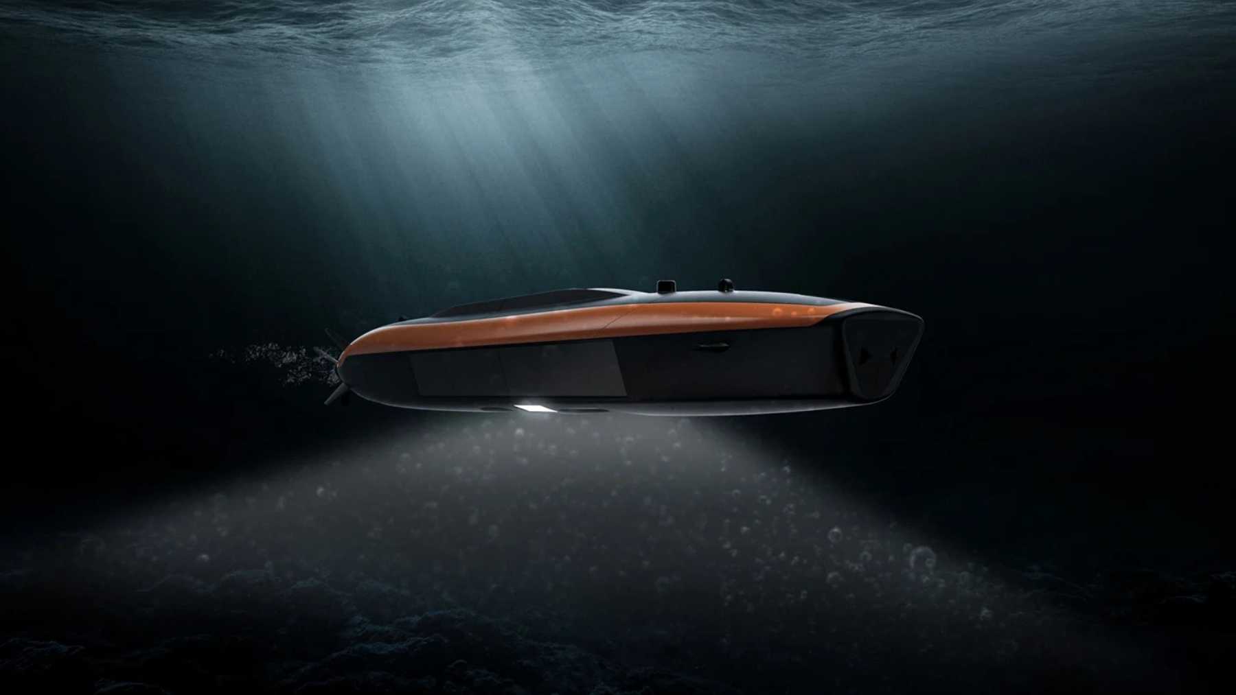
The machine that might matter more carries none of that. It’s a Norwegian survey drone called HUGIN Endurance, it has been quietly in the water since 2021, and its whole job is to go down, stay down for 15 days, and come back knowing exactly what the seabed looks like. No torpedoes, no missiles. Just a battery, a couple of sonars, and enough autonomy to run 2,200 kilometers (1,200 nautical miles) from one shore to another with no ship watching over it, and without surfacing once to work out where it is. On a single dive it can map up to 1,100 square kilometers of ocean floor, which is roughly 425 square miles, or a patch of seabed bigger than all five boroughs of New York City.
For most of its life that made it a tool for oil companies and offshore-wind surveyors. Then somebody started cutting cables. On June 8 Kongsberg, the company that builds it, signed a partnership with the Italian submarine maker DRASS aimed squarely at the wave of military demand now forming around exactly this kind of machine. The survey drone has a new set of customers, and they wear uniforms.
Fifteen Days Down, and It Never Comes Up to Check the Map
Going deep is the easy part of an underwater drone. Staying useful once you’re down there is the hard one, because the ocean takes away everything you’d normally use to find your way. GPS doesn’t reach the bottom. Radio doesn’t either. A drone that has to surface every few hours for a position fix isn’t covert, and one that needs a ship parked overhead to babysit and recharge it isn’t cheap. Solve both and you have something genuinely new. Leave either one unsolved and you have an expensive science project.
HUGIN Endurance solves both by carrying its own sense of direction. Navigation runs on Kongsberg’s Sunstone inertial system, which blends dead reckoning with terrain-referenced navigation and the drone’s own sonar to keep track of where it is without ever popping up for GPS. That’s paired with a battery good for about 15 days and a hull shaped to go the distance: swept fins wrapped over the propeller blades to protect them, reshaped tail planes to cut drag, forward fins tuned for roll stability, and slow-speed thrusters for handling below a single knot. Kongsberg’s own engineers describe the design goal as keeping the vehicle level, steady and quiet, because the entire value of the thing is being a stable, low-noise platform that nobody can hear coming.
The Sonar Is the Point. The Drone Is Just the Truck.
Strip away the endurance and HUGIN Endurance is a sensor platform, and a patient one. The headline instrument is Kongsberg’s HISAS 1032 synthetic aperture sonar, which images the bottom at roughly 5-by-5-centimeter resolution across a swath about 1,000 meters wide. Bolt on an EM2040 multibeam echo sounder for bathymetry, a sub-bottom profiler to see under the mud, and a magnetometer, and the drone produces a map detailed enough to tell a rock from something that has no business being there.
That is exactly the capability several navies have decided they’re short on. Kongsberg lists the defense jobs plainly: long-range military survey, wide-area mine detection and classification, and, in the company’s own words, “patrolling a chokepoint listening for submarines.” That last one deserves a flag, because HUGIN’s day job is mapping and mine-hunting, and the submarine-listening role is a sales pitch more than a fielded mission. But the mapping itself is the quiet half of seabed defense that nobody talks about. You cannot tell whether someone has tampered with a cable or set something down next to a pipeline unless you know precisely what that stretch of bottom looked like before. A small drone that can sit near a cable and inspect it for hours costs a fraction of keeping a crewed ship in the same spot, and a big one that can survey 1,100 square kilometers of it on a single charge is the machine that produces last week’s picture to check the new one against.
Why a 2021 Survey Drone Suddenly Has Three Defense Ministers’ Attention
The demand didn’t come from nowhere. Europe’s seabed has been losing cables and the odd pipeline in a steady drip since 2022, NATO now runs standing patrols over its own undersea infrastructure, and the alliance stood up a dedicated task force to watch for this exact kind of sabotage. Then, on May 30, the defense ministers of Australia, the United States and Britain announced the first named Signature Project under AUKUS Pillar II: a shared program of payloads and systems for uncrewed undersea vehicles, aimed at protecting more than 500 cables and pipelines, with first capabilities due in 2027.
Nine days later, Kongsberg and DRASS shook hands. The deal pairs Kongsberg’s AUVs, sonar and navigation with DRASS’s compact crewed submarines, boats that can carry and launch up to three AUVs and act as forward mother ships, plus the manned-unmanned teaming software to make them work as one system. The companies’ stated aim, in the words of Espen Henriksen, Kongsberg’s senior vice president for uncrewed platforms, is “highly capable, scalable, and interoperable underwater systems” for shifting operational and defense needs.
The framing matters here. Neither company said the word AUKUS in its own announcement, and HUGIN Endurance is not the vehicle the Signature Project is built around. That program centers on payloads and the hulls already being built to carry them, like Australia’s Ghost Shark. What the DRASS partnership does is line Kongsberg up for the surge in demand that AUKUS, NATO and a year of severed cables have created, and Kongsberg happens to already build the survey AUV a lot of those navies want.
This Is Not a Startup With a Render
Plenty of the splashy seabed-drone news this year has come from companies that didn’t exist a decade ago. Kongsberg is the opposite case. The HUGIN line goes back to the early 1990s, a dozen navies already operate HUGIN AUVs on real missions, and the US Navy took delivery of a HUGIN Superior in early 2025 after the vehicle cleared evaluation under a Defense Innovation Unit contract for large unmanned undersea vehicles. Demand got strong enough that Kongsberg started building HUGIN in the United States, at its facility in Lynnwood, Washington, rather than shipping every unit across the Atlantic. In May the company also signed an agreement with Canada’s OSI Maritime Systems to work on navigation for Canada’s next conventional submarine fleet.
None of that turns HUGIN Endurance into a submarine-hunter overnight, and it still doesn’t carry a weapon. What it makes the machine is available, proven, and already in the water, which in a field where most of the competition is a render or a single prototype turns out to be the rarest spec of all.
The drones that carry torpedoes will keep getting the headlines, and they’ve earned them. But the reason a Norwegian survey AUV from 2021 ended up in a June defense partnership is duller and probably more important. The cheapest way to find out whether someone has been quietly tampering with the cables and pipelines your internet and power run through is to have already mapped the floor they sit on, recently, in detail, without anyone noticing you were there. HUGIN Endurance has been doing the unglamorous version of that job for offshore surveyors for years. Now a growing list of navies wants the same thing, for a far less boring reason, in the same dark water.