
Most of the drone boats that make the news are small enough to tow behind a pickup. Ten feet, maybe thirty, a solar panel on top and a camera pointed at whatever somebody wants watched. The one Fugro has working Norwegian water this year is a different proposition entirely.
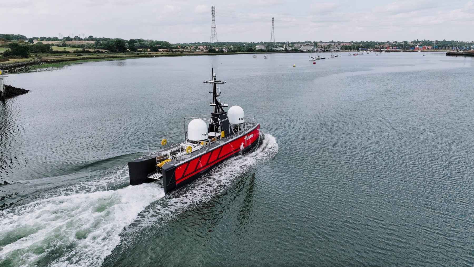
The Blue Eclipse measures 57.7 feet, carries nobody at all, and hangs its whole acoustic survey package in a pod bolted under the hull. Fugro rates it for 20 days offshore at a stretch. The people driving it sit in a control room in Aberdeen, on the other side of the North Sea, and the job in front of it covers more than 420 square miles of Norwegian seabed for a government mapping program that had never handed that work to an uncrewed vessel before.
It makes an odd pairing with the 132-pound American survey drone that went into the same sea off a tailgate. Same water, same broad job description, wildly different order of magnitude.
The pod under the hull is the actual product
The gondola is the part worth understanding. It is a faired housing slung beneath the hull, not anything you ride through Venice, and it holds the survey sensors in a fixed position below the boat.
Fugro’s published spread for the vessel runs to dual EM2040 multibeam echo sounders, an Innomar medium sub-bottom profiler, a Teledyne Echotrac E20 single beam and a Valeport sound velocity probe mounted inside the gondola itself, with an iXblue Hydrins motion reference unit and Sonardyne Mini Ranger 2 acoustic positioning behind them, according to the specification sheet published by Marine Technology News.
Putting the transducers down there is not a styling decision. Bubbles and hull noise live near the surface, and a sonar hunting centimeter-level detail in 800 feet of water would rather not listen through either of them.
The boat can also carry Fugro’s Blue Amp electric ROV, a 1,433-pound machine pulling more than 30 kilowatts that inspects to 500 meters and stretches to 1,000 meters with modification when it flies off a USV. That pairing is what turns an uncrewed boat into an inspection and light intervention platform instead of a very expensive map maker.
Twenty days is the number that changed the boat
Fugro calls this an 18-meter USV. The spec sheet says 17.6 meters, which is 57.7 feet, so roughly 40 centimeters have quietly rounded themselves into the marketing. Beam is 3.5 meters, draft is 2.5 meters, and that draft is what happens when you hang a sonar pod under a 57-foot hull.
Endurance is the real jump. Fugro’s earlier uncrewed boats run 9 and 12 meters, the 12-meter Blue Essence being the one Energy Voice credits with a part in the world’s first fully remote offshore wind ROV inspection in 2023. Those boats work fine. They just do not stay out for three weeks.
The fuel claim is the commercial argument in one line: Fugro says the Blue Eclipse burns up to 90 percent less than a conventional survey ship. That figure is the company’s own. It is also easy to believe, because a crewed survey vessel spends fuel keeping people fed, warm and dry as well as keeping sonar in the water.
Before it took the job, the hull logged more than 1,000 hours of testing and sea trials. Fugro’s six remote operations centers have run over a million hours of remote work between them.
The boat is in Norway and the watch is in Aberdeen
Fugro christened the boat in Bergen and officially launched it in Norway on February 19, 2026, after it transited over from the UK. It has been on Norwegian work since.
Aberdeen runs it over satellite. That is the model Fugro has spent years building: a room of mariners and engineers ashore, one team able to pick up more than one project, and no crew change to schedule when the forecast turns ugly.
Nick Simmons, Fugro’s USV services director, said the launch set “a new standard for uncrewed marine operations,” which is the sort of thing a director says at a christening. The 20-day figure does most of the arguing for him anyway.
The same logic is showing up all over European boatbuilding right now, from robot arms printing drone hulls without a mold to an 82-foot crewless boat stacked out of shipping containers. Take the people off and the design constraints change.
Norway wanted the fuel bill down before it wanted a robot
The job is MAREANO, Norway’s national seabed mapping program, run for the Norwegian Hydrographic Service. It maps depth and topography, sediment, contaminants, biotopes and habitats, and Fugro has been feeding data into it since 2006, more than 147,000 square kilometers of it, or about 56,700 square miles.
The current block runs to over 675 square kilometers, better than 420 square miles, in water between 90 and 250 meters deep. Fugro won it on open tender in May 2025, and it is the first time in MAREANO’s history that the data comes off an uncrewed boat.
Helge Welde, chief engineer at the Norwegian Mapping Authority’s Hydrographic Service, has been careful about what that proves. Crewed vessels stay relevant, he told Hydro International, especially for “inaccessible areas, such as the deep sea in the Norwegian Sea.” The robot gets the shelf. The ship still gets the deep water.
One timeline note, because it says something about first-of-class hardware. That same report had the boat setting course for the North Sea in August 2025. It launched in Norway the following February.
Fugro is cutting ships and buying drones in the same quarter
On July 31, Fugro published half-year results that explain this boat better than any launch video. First-half revenue came in at 920.5 million euros, up 4.3 percent, with second-quarter margin at 7.9 percent and a net result of minus 62.1 million euros after asset impairments.
The backlog is the part that stings. Twelve-month backlog fell 13.9 percent to 1.28 billion euros, with renewables down 47 percent as European offshore wind stayed slow.
So Fugro is rationalizing its vessel fleet for another 50 million euros of annualized savings and cutting 2026 capital spending to around 150 million. In the same statement, CEO Mark Heine listed what the company is still spending on, including “increasing our fleet of uncrewed surface vessels.”
Read those two lines together and the strategy is not subtle. A crewed geophysical fleet is expensive to hold through a soft market. A 57-foot boat with nobody aboard and a shore team running it is not.
America has 44 percent of its own water unmapped
Here is the American end of this. As of January 2026, NOAA’s Office of Coast Survey counted 1,726,000 square nautical miles of US waters as unmapped out of 3,878,700. That is 44 percent. The Atlantic and Gulf sit at 28 percent unmapped, the Great Lakes at 83 percent.
Part of that total grew on paper rather than shrinking: the 2026 report folded in the continental shelf beyond the 200-mile exclusive economic zone, which the US proclaimed in December 2023, pushing the area being tracked from 3,590,600 square nautical miles to 3,878,700.
NOAA’s answer rhymes with Fugro’s. In May the agency awarded 21,600,909 dollars to Chance Maritime Technologies of Lafayette, Louisiana, for up to eight uncrewed marine systems over five years, to work off two new charting and mapping ships designed from the keel up to carry them. NOAA’s own math, quoted in a Congressional Research Service report, is that agency-owned uncrewed vessels beat buying survey data outright once they work more than 70 days a year.
Fugro is already inside the American system as well. In May the US Army Corps of Engineers handed it a five-year IDIQ contract for surveying and mapping across civil works and military infrastructure, administered through the Corps’ St. Louis district and run from Fugro’s Maryland office, with the company saying it will use crewed and uncrewed platforms on the task orders. Nobody has said the Blue Eclipse itself is headed for American water, and it is not on that contract today.
What the Blue Eclipse has proven so far is narrow, and that is worth saying plainly. One hull, one program, one stretch of shelf no deeper than 250 meters, with fuel and emissions numbers supplied by the company selling the service. Norway’s own chief engineer still expects crewed ships to handle the deep work.
The number that decides the rest of it is not the 20 days or the 90 percent. It is whether a boat with nobody on it can keep hitting survey-grade accuracy through a North Sea winter, driven from a control room in another country, often enough that the accountants stop filing it under experiment. Norway gets its answer this season. The 44 percent of American water still not properly mapped waits a while longer.