
Open the ocean in Google Maps and zoom in. You’ll see ridges, canyons and trenches shaded in that deep blue, and it’s easy to assume somebody went out and measured all of it. For most of the deep ocean, nobody did. Those shapes are estimates, worked out from satellites reading tiny bumps and dips in the sea surface, and stitched together with old ship tracks and soundings that in some places go back a century. The federal government has a plan on the books to fix that for American waters, and a chunk of it just got done by a boat with no crew.
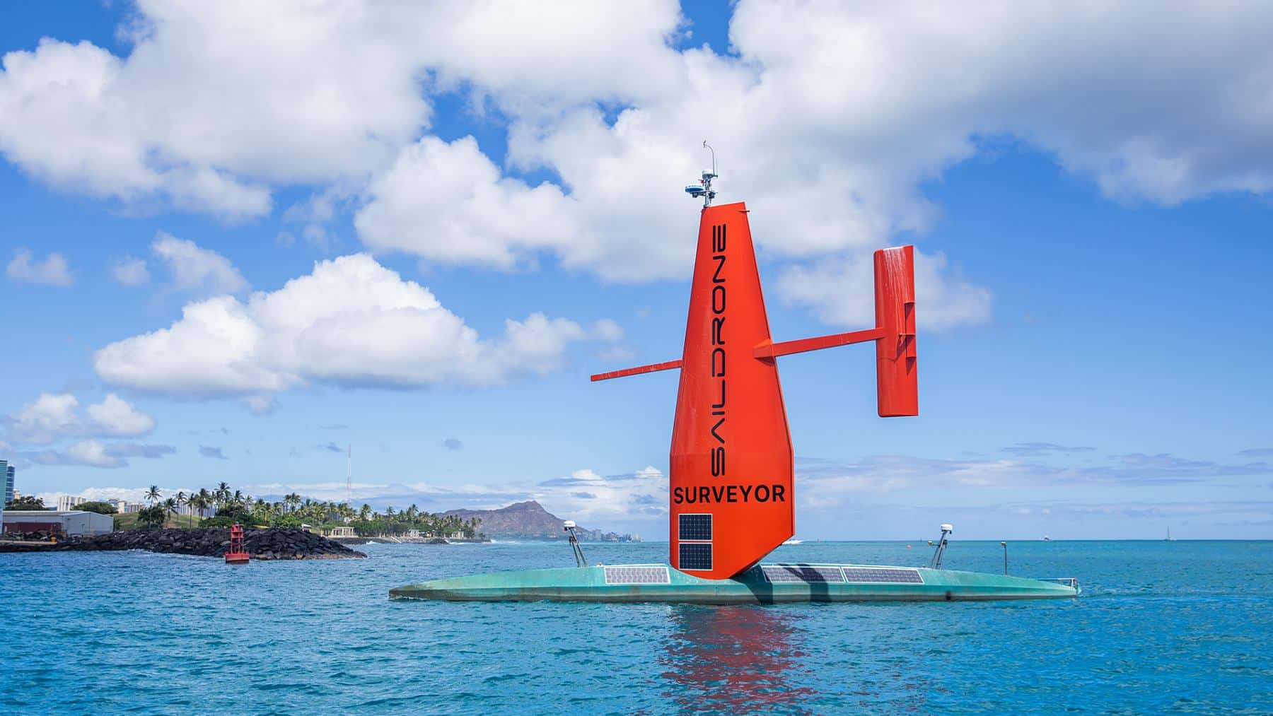
The boat is the Saildrone Surveyor, a 65-foot drone ship built in Alabama. According to Saildrone’s October 14 report on the mission, one Surveyor spent six months off the eastern side of the Mariana Islands, in the US Exclusive Economic Zone, and mapped more than 16,000 square nautical miles of seafloor at depths between 1,235 and 6,378 meters. In American units, that’s 4,052 to 20,925 feet. The deepest sounding on that job is deeper than Denali is tall.
And if 16,000 square nautical miles doesn’t mean much to you, it works out to roughly 21,000 square miles, which is a bit more than Massachusetts and New Jersey put together, measured strip by strip by one 65-foot boat that nobody was steering.
So how does a boat that size do that much work on its own?
So what is a Saildrone Surveyor?
Picture a racing yacht with the mast swapped for an airplane wing stood on end, and nobody in the cockpit. The production Surveyor is 20 meters long (65.6 feet), weighs 15 tons, draws about 12 feet of water and carries a 43-foot rigid wing. Austal USA builds the aluminum hull and keel in Mobile, Alabama, and Saildrone builds the composite wing and the electronics at its headquarters in Alameda, California. The first production boat, SD-3000, came off that line in Mobile, and Austal said at the time it could turn one out every six weeks.
The propulsion is what I find pretty clever. An 80-horsepower diesel does the actual pushing, and the wing works as a free assist whenever the wind cooperates, which cuts the fuel burn enough that Saildrone rates the boat for 100 days at sea between service stops. It maps at 6 knots, so about 7 mph. That’s slow, and that’s fine, because speed isn’t the point here. The point is staying out there for months without anyone needing to eat, sleep, or go home.
Under the hull sits a Kongsberg EM 304 MKII multibeam sonar. If you haven’t run into multibeam before, the idea is simple enough. An old-fashioned depth sounder pings straight down and gets one number back. A multibeam fans a wide swath of sound out to both sides, times the echoes as they come back, and paints a strip of seafloor on every pass, so you end up with a 3D map instead of a line of dots. Saildrone rates this one for depths down to 11,000 meters, about 36,000 feet, so the Mariana Trench itself, the deepest spot on the planet at 35,876 feet, is technically within its reach. This mission didn’t go there. It worked the shallower terrain east of the islands, if you can call 20,925 feet shallow.
One more thing you may be wondering: why are the Mariana Islands “US waters” at all? Guam and the Northern Mariana Islands are American territory, and every country gets an Exclusive Economic Zone out to 200 nautical miles from its coastline. So that stretch of the western Pacific counts toward the federal mapping goal just like the waters off Maine do. It’s also one of the biggest blank spots in the whole US EEZ, because it’s extremely deep and extremely far from anywhere you’d want to base a survey ship.
Why send a boat with nobody on it?
Because the crewed ships are busy. Saildrone says traditional survey vessels are booked years in advance, and frankly I believe it, because there aren’t many of them and the ocean is large. A crewed survey ship parked off the Marianas for six months means salaries, food, fuel and crew rotations for everyone aboard, plus the transit each way, and you’re paying all of that whether the sonar is on or not. A 15-ton drone means a shore team watching screens.
Kitch Kennedy, a retired Navy captain who runs ocean mapping at Saildrone, put it this way: “Deepwater hydrography has always been constrained by access and time on station.” That’s the company talking, but the numbers back him up.
Did it actually finish the job it was sent to do? Yes, and then some, which I’ll admit I didn’t expect. I went back and read Saildrone’s February 24 announcement of this mission, and the contract called for 13,000 square nautical miles, with the work expected to wrap up in May. The boat came back with more than 16,000. Saildrone hasn’t published the start and finish dates, which hull it was, or how much diesel it burned, which is a slightly odd set of things to leave out of a mission report, but the area and the depths are there and those are the figures that matter.
The data didn’t sit on the boat, either. The survey was run for NOAA’s Ocean Exploration program and its Office of Coast Survey, with a company called Woolpert holding the NOAA contract and processing the soundings into finished charts. Woolpert got the raw data in near real time over satellite as the Surveyor collected it, so somebody on shore could check the quality of each strip while the boat was still out there. There’s no waiting months for a hard drive to come home. Saildrone’s spec sheet lists a Starlink terminal on the Surveyor, so a boat in the middle of the Pacific apparently gets better upload speeds than my apartment.
For the record, the Marianas job isn’t the company’s biggest. Saildrone’s Cayman Islands survey covered about 90,000 square kilometers, roughly 34,700 square miles, over something like 300 mission days. But as far as I can tell it’s the deepest water Saildrone has worked for NOAA, and it sits squarely inside the 2030 target.
The Navy wants the same trick in the Atlantic
We covered the Surveyor a month ago when the Navy’s Naval Oceanographic Office handed Saildrone a $10 million task order to map stretches of the open Atlantic, starting before the end of this year and running through most of 2027. That announcement came out on September 15, and at the time the Marianas results hadn’t been published. Now they have, and they’re arguably the better advertisement for the Atlantic job than anything in the Navy press release, because six months alone in the western Pacific is exactly the kind of long, dull, far-from-port deployment the Navy is paying for.
The federal goal driving all of this is NOAA’s national strategy for mapping the US EEZ, which calls for the deep water to be mapped by 2030 and the nearshore by 2040. Saildrone shortens that to “all US waters by 2030” in its own materials, which isn’t quite right, but the Marianas work is deep water, so 2030 is the date that applies here.
Saildrone’s whole fleet, from the 23-foot sailboats up to the Surveyor, has now logged more than 2 million nautical miles and 60,000 days at sea, by the company’s count. One of those smaller boats is out circling Antarctica right now on a 200-day run, and the Navy has started letting its big drone submarines cross the Pacific on their own too. NOAA and the Navy have pretty much handed the patient, repetitive end of ocean work to the machines, and from the looks of things they’re fine with that.
Saildrone published the Marianas results on October 14, 2026. Woolpert delivers the processed charts to NOAA’s Office of Coast Survey under its own contract, and the Surveyor fleet is due in the Atlantic for the Navy before the year is out.
Image Credit: saildrone.com