
Your phone’s GPS has probably tried to talk you into a shortcut you didn’t want. The Mississippi River has been staring at one of those for about 75 years, and the Army Corps of Engineers keeps telling it no.
About 50 miles northwest of Baton Rouge, the Mississippi still has 315 miles to go before it reaches the Gulf of Mexico. There’s a side door there, though. Go down the Atchafalaya River instead and the trip’s just 142 miles, according to a Corps brochure on the project, and by 1951 engineers could see the big river would switch to that route if nobody stepped in.
So why not let it? You probably wouldn’t love the result. The Corps says the channel past Baton Rouge and New Orleans would end up a saltwater estuary, and that’s bad news for the refineries lining its banks and the cities that drink from it. So Congress authorized a fix in 1954, and the workhorse of that fix is a 566-foot concrete structure called the Old River Low Sill.
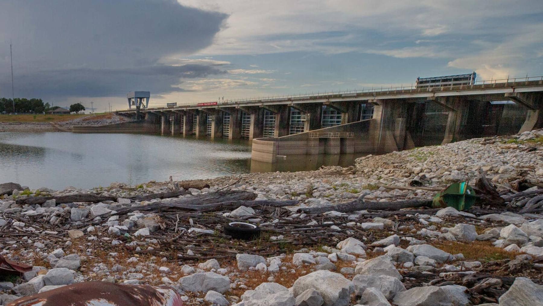
The Corps calls it a control structure. Its own researchers say it resembles a dam, which seems fair: 11 gates, each 44 feet wide, sitting on 1,920 steel H-piles. The difference is that it’s supposed to let water through. I couldn’t find a published weight for it, unfortunately. Along with its sister structures, it runs by one rule: about 30% of the combined flow of the Mississippi and the Red River goes down the Atchafalaya each year, matching what the rivers were doing on their own in 1950.
It’s also been living with foundation damage since a flood in 1973. The Corps recently pumped some of its gate bays dry for maintenance, and its researchers used the chance to weigh the ground underneath, looking for holes.
So what did they find?
I couldn’t find a published answer, and I’ll get to why that doesn’t automatically mean anything scary.
So what happened in 1973?
The river stayed above bank-full for 95 days that year at Knox Landing, about a mile downstream. In April, an eddy (a swirl of water that doubles back on itself) formed behind the south wing wall, the 67-foot concrete wall that guided water into the gates. Most of that wall collapsed on April 12.
Then the current went to work on the foundation. It carved out a void up to 55 feet deep in front of the structure and under it, according to a paper from the Corps’ Engineer Research and Development Center, or ERDC (a 1979 Army paper says 65 feet at the deepest point out front). The brochure says about 50 feet of the steel piles ended up exposed, and ERDC says those piles go 90 to 116 feet into the ground. Engineers call this scour. Basically, moving water takes the riverbed out from under whatever’s standing on it, and we looked at the same kind of problem at a much smaller North Carolina lock and dam just this week.
The fix was a pretty brute-force affair. The Corps dumped 98,000 tons of rock to replace the wall and another 118,000 tons into the hole out front. Then it pumped in about 33,000 cubic yards of grout, a runny cement mix that levels itself out, to fill the void under the structure. Borings done afterward found continuous grout from the bottom of the slab down to the bottom of the cavity, according to a 1979 Army paper. And the structure’s still passing water 53 years later. But the brochure says the flood left the foundation permanently weakened, and that’s why the Low Sill now lives under a limit.
The Low Sill has a speed limit
Engineers call the number that matters here head. It’s just the difference in water level between the two sides of a structure, in this case the Mississippi side and the Atchafalaya side. The higher it gets, the harder the water shoves.
ERDC’s engineers put the original design at 35 feet. The Corps’ 2009 brochure says 37. I can’t tell you why they don’t match, but ERDC’s reports are newer and a lot more technical, so I’m going with 35. Either way, the number that counts today is much smaller.
A stability analysis after the repairs led to a limit of just 13 feet, and to a second structure called the Auxiliary, with six 62-foot gates, finished in December 1986 for $206 million. The limit was later relaxed to 22 feet, which that ERDC paper, reissued in March 2025, calls the current level. That’s a serious haircut for a structure that’s still expected to do its original job. Hoover Dam has a number it has to watch, too, though that one’s about how low the lake gets.
Figures: ERDC, US Army Corps of Engineers New Orleans District.
You’d probably figure a big flood is when head peaks, but from the looks of things it’s not that simple, since both sides come up. On May 23, 2011, ERDC’s paper has the river side at 65.2 feet and the Atchafalaya side at 50.9, for a head of 14.3 feet. I couldn’t find a public daily log of head, so I can’t tell you how close the Low Sill gets to 22 in a normal year.
How do you see under a dam full of steel?
That’s been the problem for years. Steel carries electricity and sound so well that it interferes with the methods geophysicists normally lean on. So when ERDC ran electrical and seismic surveys from boats in December 2019, it couldn’t get a read directly under the structure.
The survey still turned up some useful stuff close by. An April 2022 report on it found no evidence of air-filled or water-filled voids more than about 10 feet across in the repaired area, and it described the fill as a patchwork of grouted rock and rock mixed with river sediment and water. It also said smaller pockets could be down there without the survey picking them up.
What ERDC needed was a method the steel wouldn’t throw off, and a chance to stand right on top of the structure. That chance most likely traces back to a $34.2 million contract the Corps awarded in 2023 for a steel system to pump the Low Sill dry, with the work planned for the low-water months of 2024. The Corps said it’d be the first dewatering since 1987. I couldn’t find a date for when the bays actually went dry, and ERDC’s update only says the survey happened “recently.”
The method it picked, microgravity, is a pretty neat trick. A gravimeter measures tiny differences in the pull of gravity at a given spot, and less mass underfoot means a slightly weaker pull. “If there’s a void, we should see a low point in the gravity readings,” ERDC research geophysicist Rebekah Lee said in the center’s February update. So you’re basically weighing the ground from up top without digging it up. ERDC says the method gets around the interference from the piles without spelling out how, and my guess is it helps that every bay being compared has them.
The team measured bays 8 and 9, which sit over the old scour, and bay 4, which the flood left alone. Think of bay 4 as the control group. That choice lines up with the 1979 paper, which put the deepest cavity, 52.2 feet, under bay 11, shrinking to 1.8 feet under bay 7.
So did they find anything?
I can’t tell you. ERDC’s update, published February 23, says the data was still being processed, and I couldn’t find a published result from ERDC or the Corps’ New Orleans District since then. ERDC’s boat survey took from December 2019 to April 2022 to come out as a report, so I wouldn’t read anything into the wait in either direction.
You also shouldn’t assume there’s a hole down there, because nothing ERDC has published says so. Its most recent stability paper is fairly reassuring, if anything. It found the uplift pressure under the structure (water pushing up from below) runs higher than the original design assumed but lower than the worst case engineers plugged in after the flood, and it says the way the structure has behaved backs up the limits it runs under now.
That paper also hints at why anyone wants better data. It says the limit has made it hard for the structure to keep up with the flows it’s meant to carry, and that engineers would need to know more about the grout before changing it, starting with core samples. So I’d guess this survey isn’t only about peace of mind. It could also help decide whether the Low Sill gets a little more room to work.
The river isn’t making this any easier
There’s a good reason to want that room. The Mississippi’s been filling in its own bed around here. A 2021 ERDC technical note cites a loss of about 40 to 45 feet of channel depth at river mile 315.5 between 1975 and 2008. It attributes the sediment buildup to a 1930s program of cutoffs, which shortened the river by slicing through its bends, and to the hydroelectric plant next door. That plant’s a 25,000-ton prefab that got hauled 208 miles upriver from New Orleans, which is frankly a story for another day.
A shallower channel means the river runs higher for the same amount of water, and that pushes head up. The note says the low-water reference level in the Low Sill’s approach channel rose from 9 feet in 1963 to 15 feet in 2019, and it warns that another 4 feet in about 40 years would take the structure past its 22-foot limit. It also admits those surveys didn’t all use the same reference point and asks for new ones to pin that down, so I’d take the forecast as a direction more than a date.
Meanwhile, the complex keeps working. A Corps notice to mariners had it sending a lot more water through the structures from 7 a.m. to 5 p.m. on August 13 and 17, for what it called auxiliary flushing, and it warned boats around Simmesport to be extremely careful. The notice doesn’t explain the job, though the name suggests clearing out sediment.
You can check one side of that head yourself. The National Weather Service’s Low Sill gauge works like the Baton Rouge one we walked through while the USS Kidd was waiting on the Mississippi to rise, and since it’s listed on the Mississippi side only, I can’t do the subtraction for you. It read about 31 feet on October 6 and 20.96 feet at 5 a.m. local time on November 4.