
If you’ve ever flown into Phoenix, you’ve seen the Salt River, whether you knew it or not. It’s that wide strip of dirt and gravel just south of Sky Harbor’s runways, and for most of the year, it’s about as wet as the airport parking lot. Salt River Project, the utility that runs the reservoirs upstream, calls it the “normally dry Salt River” right there in its press releases.
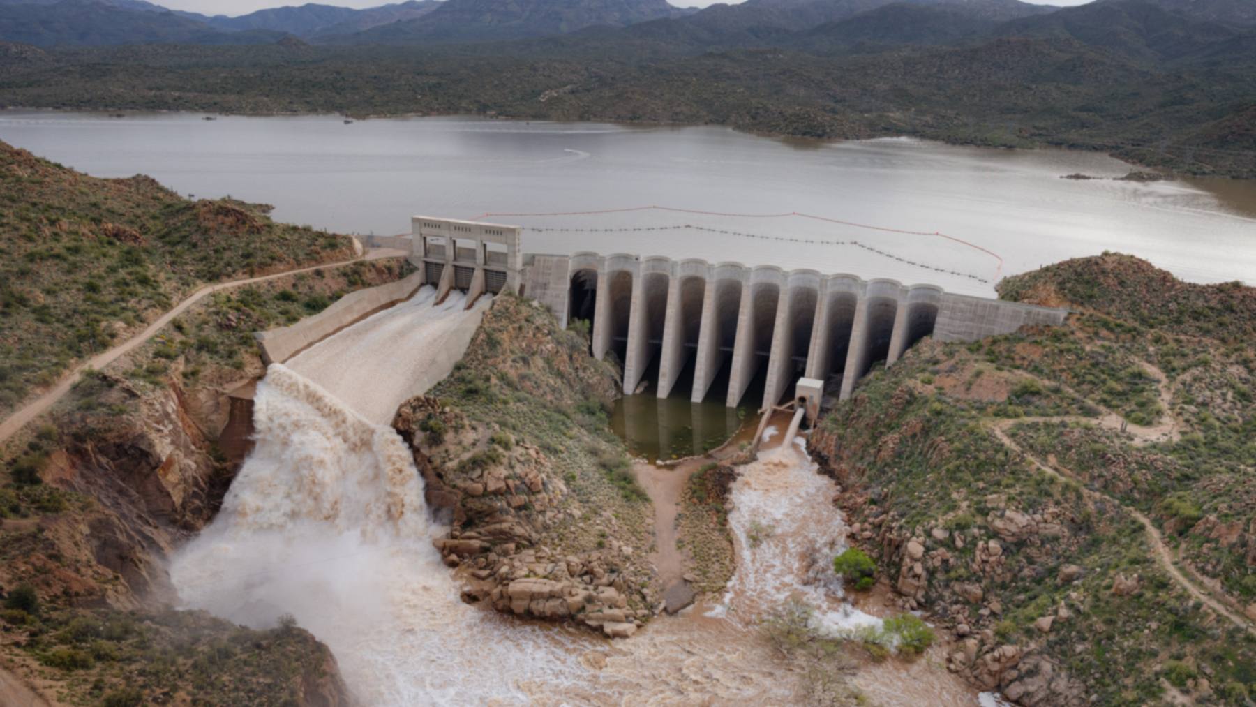
This week, it’s a river. And most of what’s in it came through one 87-year-old dam that used to hold a world record.
That’s Bartlett Dam, on the Verde River, about 48 miles northeast of Phoenix. SRP’s senior hydrologist, Jacob Richardson, told KJZZ on November 3 that Bartlett had been letting out about 60,000 cubic feet of water per second the day before. He also said the last time SRP pushed that much through it was “probably 1993.” I’m keeping that “probably” in there, because he’s the guy who’d know and even he isn’t swearing to it.
So how much water is 60,000 cubic feet a second?
By my math, it’s about 449,000 gallons. Every second. You could fill an Olympic pool in roughly a second and a half, and you could run all of Bartlett Lake through the dam in about 36 hours. SRP’s Daily Water Report lists Bartlett’s normal release at 555 cubic feet per second, so 60,000 is somewhere north of 100 times that.
I do have one caveat. That 60,000 came from Richardson on the radio, and as far as I can tell, SRP hasn’t published that figure for Bartlett in writing. The last press release SRP put out about this, from the evening of November 1, says about 54,000 cubic feet per second, and that’s Bartlett and Stewart Mountain Dam added together. A notice on SRP’s website does warn that combined flows could top 60,000, so the ballpark holds up.
So why is there water in the river at all?
The Salt runs dry through town on purpose. Just below the spot where the Verde joins it, there’s a low structure called Granite Reef Diversion Dam, and it isn’t there to store anything. It steers the river into two big canals that carry the water off to Valley homes and farms. On a normal day, the canals get pretty much all of it, and the riverbed below gets next to nothing.
Anything the canals can’t take goes over the top. SRP’s November 3 report had them pulling 570 cubic feet per second, with 39,681 going over Granite Reef and on through the Phoenix metro toward the Gila River. Which means you’ve got a canal system sipping from a fire hose.
The reason there’s so much of it is that the Verde has had an absurdly wet fall. SRP expects October and November inflows there to top anything since 1972, at about eight times the average, and that’s right after three straight low-runoff seasons. Richardson told AZFamily he’d heard the rain on the watershed pegged at something like a once-in-150-years event. The same storm sent water over the top of the Watson Lake dam in Prescott on November 1, way up in the Verde’s headwaters. Bartlett’s just the big federal dam near the bottom of the hill that has to deal with all of it.
Why isn’t Roosevelt Lake letting anything go?
You might be wondering about this one, since Roosevelt is the giant everyone in Arizona knows. According to Richardson, the Salt has gotten about as much water as the Verde this time around. It simply has way more room to put it.
Add up the columns in SRP’s report and the Salt reservoirs hold about 2 million acre-feet when they’re full, while the Verde’s two lakes hold about 287,000. An acre-foot is what it sounds like: enough water to cover an acre one foot deep, or roughly 326,000 gallons. So the Verde is working with about a seventh of the space.
That gap shows up in the November 3 numbers. Bartlett Lake was 97% full, only about 2 feet below the top of its normal storage level. Roosevelt was 59% full, even after picking up 103,693 acre-feet in 24 hours, and that’s more than half a Bartlett Lake in a single day. Canyon Lake, farther down the Salt, was at 37% because SRP pulled it down 54 feet this fall to sandblast the gates on Mormon Flat Dam. That’s arguably lucky timing, although I haven’t seen SRP say it made any difference.
So does all this water help?
Some of it does. Richardson told KJZZ this is the kind of storm SRP counts on to fill its lakes, and he seemed pretty happy about it. The cities and irrigation districts SRP supplies also get a shot at the extra water. The frustrating bit is what happens to the rest. Once it crosses Granite Reef, SRP can’t pull it back, and most of it keeps going to the Gila.
A share of it does seep down into the aquifer. Richardson said SRP has estimates for how much, but he didn’t give a number on air, and I couldn’t find one anywhere else.
It’s a bit of a strange thing to watch in a state that’s been staring down Colorado River cuts for years, although SRP’s system is separate from the Colorado. And it isn’t the whole region, either. Over in New Mexico, Elephant Butte was still under 5% full in mid-October, even after a hurricane’s leftovers tripled it.
Bartlett was the tallest of its kind once
When it was finished in May 1939, Bartlett stood 286.5 feet tall, and the National Park Service calls it the “highest multiple arch dam in the world” at that point. It was also the first dam of that type the Bureau of Reclamation ever built.
If you’re picturing Hoover, don’t. Hoover’s a massive wedge of concrete. A multiple arch dam is a row of thin, curved concrete shells leaning on buttresses, and Bartlett has 10 arches and nine buttresses, with the buttresses left hollow.
The point was money. It was the Great Depression, so thin arches meant less concrete to buy and haul, and all those fussy shapes meant more work for people who badly needed it. The job came in $270,000 under budget, which I can’t imagine happens much anymore.
The Verde apparently didn’t care for any of this. On February 7, 1937, with the first concrete just two days old, the river crested at 62,500 cubic feet per second. A year later, in March 1938, it hit 108,000. The contractors, the Park Service notes, had bought flood insurance. Smart guys.
Today’s dam is taller. Reclamation raised it 21.5 feet between 1994 and 1996 so water couldn’t go over the top, and it now lists a structural height of 308.5 feet and an 823-foot crest. I can’t find a published weight. Reclamation does list 182,000 cubic yards of concrete in the original dam, though, and at roughly 2 tons a cubic yard, my rough math puts that at something like 360,000 tons before the raise.
That same job added a backup spillway with what’s called a fuseplug, which is basically a section of earthen embankment built to wash out on purpose if the lake ever gets high enough. Nothing I’ve read says it came into play this week. Reclamation lists spillway capacity at 287,500 cubic feet per second with the lake at its 1,821-foot maximum, so 60,000 is about a fifth of that, and the lake was sitting around 1,796 feet on November 3.
And 1993 was a different animal. The Arizona Geological Survey puts Horseshoe Dam, the next dam up the Verde, at about 110,000 cubic feet per second near its peak that January, and a stream-gauge study has the river below Bartlett topping out at the same figure on January 8. So this week’s 60,000 is the biggest in a long time and still only a little over half of that.
The old dam could end up underwater
SRP and 23 partners are working with Reclamation on a feasibility study for the Verde reservoirs, which SRP says have lost about 50,000 acre-feet of storage to sediment. The option SRP favors, according to its project page, is a new, larger Bartlett Dam that would lift the lake about 100 feet and add up to roughly 323,000 acre-feet. That would nearly triple what’s there now.
My favorite detail is what happens to the 1939 dam. It wouldn’t get hauled off. SRP says crews would pull the spillway gates, cut windows in the arches so water can pass through, and let the bigger lake swallow it.
Don’t hold your breath, though. SRP estimates $2.6 billion to $3.7 billion in total, it expects Reclamation to send a report to Congress by late 2028, and design and construction could take 10 to 15 years if Congress signs off. That page was last updated in July 2025, so some of those dates may have moved. Still, a river full of water you can’t keep is arguably the best sales pitch that project could ask for.
How long is the Salt going to run?
Richardson told KJZZ the Salt should keep running for days and maybe weeks. Weatherboy, relaying 12News, has him saying the releases could go on for up to two weeks. If you live in the Valley, you already know the rest. SRP says several East and West Valley roads built across the riverbed are closed, which is about what you’d expect when you put a road in a river and the river shows up.
Tempe Town Lake is closed to boats too, and 12News reported that firefighters had to pull a man out of a tree where Loop 101 meets Loop 202. So please don’t drive around the barricades. Your truck isn’t that good. AZ511 has the current list of closures.
The National Weather Service’s flood warning on the Salt and Gila runs through 2 p.m. MST on Saturday, November 7, and SRP’s November 3 report had Bartlett down to 27,936 cubic feet per second, about 50 times the 555 it lists as normal.