
Most big dams treat the top of the wall as the one place water should never go. When a flood shows up, it gets sent around the dam, through a concrete chute off to one side or a row of gates somebody can open and close. Water going over the crest is usually what dam engineers spend their careers trying to prevent.
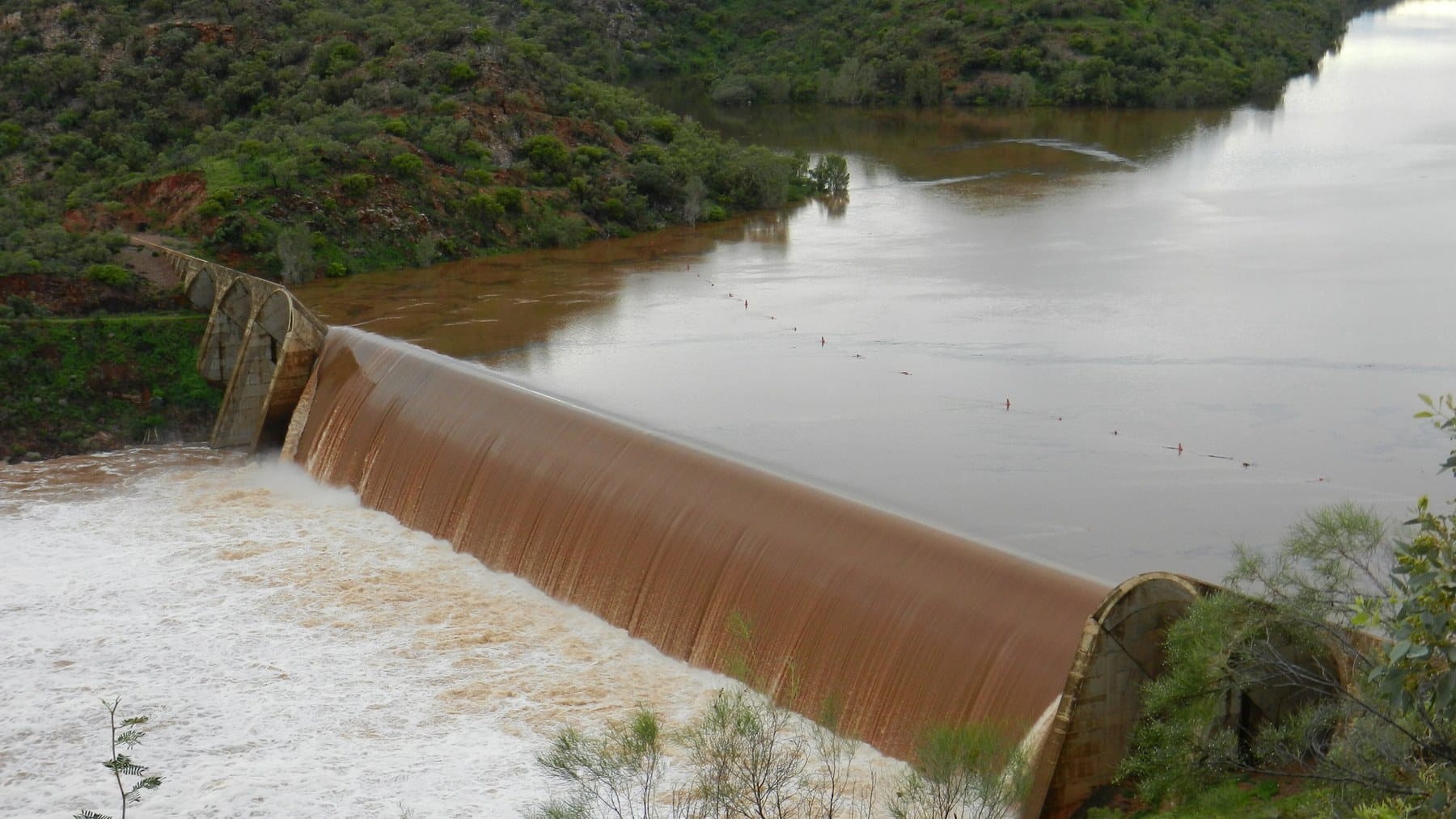
Julius Dam, in the outback of northwest Queensland, Australia, does pretty much the opposite. It doesn’t have a separate spillway. When the lake behind it is full, the extra water just pours over the tops of its concrete arches and drops into the Leichhardt River on the other side.
ABC News ran a feature on the dam on November 1, pegged to its 50th anniversary. One of the people it talked to was Alexander Scheuermann, a geotechnical engineering professor at the University of Queensland, and he told the ABC his first thought on seeing it was “Where’s the spillway?”
Fair question. So I went through the emergency action plan that Sunwater, the dam’s operator, has to get approved by Queensland’s dam safety regulator, to see how a wall that’s built to be overtopped actually deals with it.
So what does this thing look like?
Picture a row of concrete half-pipes lying on their sides, each one tilted back into the lake and propped between two triangular concrete walls. That’s basically it. Sunwater calls it a multiple-arch and buttress dam, and says it’s the only one built that way in Queensland.
The arches take the push from the water and hand it off sideways to the buttresses, which are those triangular walls. The buttresses then pass the load down into the rock. A gravity dam does the same job by being so heavy the lake can’t shove it downstream, which is why the arch version gets away with a lot less concrete.
The wall runs 1,310 feet along its crest, according to the plan. At its tallest, it stands 117 feet above the lowest point at its downstream base, and it drops to 87 feet through the middle section where the water goes over.
That middle section is the spillway, and it’s about 720 feet long. Sunwater’s plan says it’s capped with precast ogee crest slabs. An ogee is the S-shaped curve you see on the lip of most spillways, and it’s shaped so the water hugs the concrete on the way down instead of launching off the edge.
You may be wondering if America has anything like it. We do, sort of. Pensacola Dam on Oklahoma’s Grand River lines up 51 concrete arches across about 4,284 feet, but its operator sends floods through a separate spillway section. Julius skips that step entirely.
So why build a dam you’re supposed to pour a river over?
Mostly because of where it is. Sunwater puts the dam about 43 miles northeast of Mount Isa, a mining city that’s a long way from anywhere. (Its emergency plan says about 75 miles instead. My guess is that one’s by road, but the plan doesn’t say.) William Weaver, who runs operations for Sunwater’s northern region, told the ABC that the site’s remoteness and the trouble of getting materials out there were what pushed engineers toward this design.
Less concrete means fewer trucks. The original plaque, as the ABC reported it, puts the whole dam at about 59,000 cubic yards of concrete. Oregon’s Detroit Dam, a concrete gravity dam we covered this week, used about 1,357,000 cubic yards. Detroit’s nearly four times taller, so that’s not a fair fight, but it gives you an idea of how lean this design is.
Frankly, it’s a pretty elegant answer to a trucking problem.
The other half of the trick is that concrete doesn’t mind water running over it the way an earth dam would. Pour a river over a dirt embankment and the river starts carrying the dam away. Pour it over a smooth concrete crest and, according to Scheuermann, it goes over without hurting the structure. You also don’t need to cut a whole second channel into the hillside for floods, which I’d argue was part of the appeal, although Sunwater doesn’t spell that out.
How deep does the water get on top?
Deeper than you’d probably expect. The emergency plan lists the five biggest floods the dam has taken, and the worst came in January 2004, when the lake peaked 15.2 feet above the spillway crest. March 1997 came within about 4 inches of that, at 14.9 feet.
The design goes further. Sunwater’s plan says the spillway was built for about 487,000 cubic feet per second, and a 2022 risk assessment found the dam can pass a 100-year flood over the spillway without any water going over the higher sections at either end.
A 100-year flood doesn’t mean one every century, by the way. It’s a flood with a 1% chance of happening in any given year, so you can get two in a decade if you’re unlucky.
Those higher end sections are called abutments, and they’re where the dam ties into the sides of the valley. They sit about 30 feet above the spillway crest and aren’t meant to carry water. The plan flags erosion around the abutments and of the foundation just downstream as the main way a big flood could threaten the structure, especially if the water ever got high enough to go over those end sections.
There’s one more line in there I found pretty interesting. Once the lake gets about 6.4 feet over the crest, Sunwater goes on alert for something called nappe vibration. The nappe is the curtain of water falling off a spillway, and under the wrong conditions that curtain can start to oscillate against the structure behind it.
Alert is the first rung on Sunwater’s emergency ladder, and it basically means more inspections and more people watching. Both of the big floods above went well past that mark. I can’t find anything public saying whether nappe vibration has ever actually caused a problem here, so I wouldn’t read too much into it.
So what’s the water actually for?
Backup, mostly. Mount Isa’s main supply is Lake Moondarra, a reservoir closer to town that Mount Isa Mines built in 1958, according to the ABC. A drought in 1971 showed the city that one lake wasn’t enough, and Julius was the fix.
Lake Julius holds about 87,000 acre-feet at full supply, or roughly 28 billion gallons. Sunwater says that water also goes to Cloncurry and to mines in the region, including the Ernest Henry copper mine and MMG’s Dugald River operation. The ABC reports a 70-mile pipeline built in 1998 that feeds the Ernest Henry area, and a 24-mile line to Cloncurry that came along after a later drought.
Day to day, water leaves the lake through a 36-inch pipe that runs out between the fifth and sixth buttresses, controlled by a 24-inch cone valve. Weaver told the ABC the dam has spilled every year for the past decade, thanks to monsoon and cyclone rains refilling the catchment. He also said a seven-person team based in Cloncurry runs the dam and its pipelines, which seems like a pretty lean crew for a water system that a whole mining region leans on.
If the name rings a bell, you might be thinking of Tanzania’s Julius Nyerere dam, which we covered in August. Different Julius. This one’s named after Julius Kruttschnitt, a former Mount Isa Mines chairman.
So how old is it, exactly?
That depends on which Sunwater document you read. The ABC says work ran from 1973 to 1976 and that the dam was officially commissioned on October 8, 1976. Sunwater’s emergency plan and its dam statistics sheet both say it was completed in 1976, while the dam’s own page on Sunwater’s website says 1978.
I’d go with 1976, since three sources line up on it. I just can’t tell you where the website’s date came from.
Either way, Scheuermann told the ABC that dams can keep working for more than a century, as long as there are skilled people and engineers around to keep checking them. Sunwater’s plan has the dam on a schedule of routine visual checks, a detailed inspection every year and a comprehensive one every five, plus 14 survey points on the spillway that get watched for any settling. That’s arguably the boring stuff, but it’s exactly what you’d want on a dam that has a river running over it most wet seasons.
If you were hoping to see it in person any time soon, the timing’s not great. Sunwater has closed the recreation areas and boat ramp at Lake Julius from Tuesday, November 3, through Friday, December 18, weather permitting, while it upgrades the facilities there as part of a Queensland Government program.